Showing posts with label googlemaps. Show all posts

Saturday, 20 December 2008

Google Earth - New York in 3D

I promise to post something technical soon - but for now here's another OT post...

russ sent this news on the latest Google Earth update with New York in 3D. It looks awesome! Since I was only just in New York, I decided to compare a couple of photos with Google's rendering...

First, here's my photo from "Top of the Rock" at Rockefeller Center:

and Google's


And this is the view from the Westin on 43rd and 8th

and Google's (had to make a rough guess on the position of my window)


Can I have my city in 3D too now, please?


Wednesday, 15 October 2008

Silverlight 2.0 'live'

Everyone knows by now that Silverlight 2.0 has been released, and Silverlight-enabled websites everywhere are scrambling to update their beta2 code.

Two conceptdevelopment.net sites have been updated:
racereplay.net and others still to come...

Sunday, 21 September 2008

SilverlightEarth updated for rc0

If you have been updating your Silverlight 2.0 beta 2 for Release Candidate 0, you will probably be familiar with this error "Failed to load the application. It was built with an obsolete version of Silverlight":

Even if your code is 100% RC0 'compatible', you need to re-compile your Silverlight assemblies with the RC0 Silverlight Tools for Visual Studio.

For example, SilverlightEarth.com/2 is updated for RC0, and SilverlightEarth.com/2b2 still hosts the beta2 bits. Although no code changes were required (or made), there a minor visual differences that I have yet to correct (the height of the radio-button StackPanels, for example).

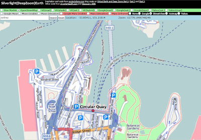
SilverlightEarth.com hosting OpenStreetMap with the Google StreetView overlay

Slightly OT: GIS in XML blog posted recently about
Virtual Earth - DeepEarth - Deep Pockets. Basically it calculates a cost of approx. $1.25 per viewer if licensing Microsoft's Virtual Earth tiles for use in DeepEarth (Silverlight 2.0 map tile client)... although Microsoft can't be too concerned since they have it listed in their Community Gallery!

Luckily silverlightearth.com/2 offers OpenStreetMaps and NASA Blue Marble imagery...

Way OT: the Deep Zoom Tag Cloud example also updated for RC0

Wednesday, 14 November 2007

Virtual Earth 6 - new map 'shading'

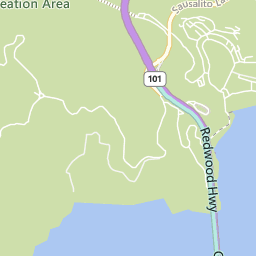
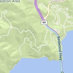
Microsoft Virtual Earth 6 has been released - along with various different improvements to the "UI" (javascript and the controls that drive it), one noticable difference is the addition of 'topographical shading' in Road view. Here's the Golden Gate Recreation Area 'before' and 'after'...


Of course, SilverlightEarth.com now uses the new tiles - visit San Francisco and switch between (road) and (roadshade) views.

Seems to be available "down under", but only to zoom '13' and no closer...

(thanks to via windows live and Darren Neimke for the heads-up)

Monday, 12 November 2007

Silverlight 'map tile client' finds a home - SilverlightEarth.com

While the map tile client isn't quite yet for release, I'd already paid for the domain so decided to post it anyway... which means

SilverlightEarth.com

is now LIVE! Granted the dragging still doesn't work; but keyboard (arrows, page up, page down to zoom and pan) does, and the mouse-wheel zooms too. The search box 'searches' and the 'link to this page' does just that.

What's still to come? Well centering the search location for a start, then proper drag-panning on mouse-still-down. After that - maybe uploading some form of geo-coded Xaml to overlay directly on the map... and finally animation a-la RaceReplay.net.

While I had already started working on the 'tile client' before coming across FlashEarth, that is basically the kind of result I'd like to get from Silverlight. Of course, since the Silverlight 1.0 version is (will be) Javascript-based, the code will be easily available for all to see...

Tuesday, 16 October 2007

Pretty Xaml and Search

The Silverlight Virtual Earth/Google Maps tile client v0.9 now has a few more features:
  • Search box to 'geocode' a search term and set the map to that location (eg. search for sydney cricket ground or london eye)
  • Search also accepts latitude, longitude coordinates (searching for 51.505,0.0 will get you pretty close to Greenwich)
  • Xaml controls for the map type, pan and zoom controls

Note that the search results currently default to map zoom '9' -- you should see the flag marker on the map in the top-left -- simply select zoom 14/15/16 to get closer to your target. This will be updated in a future version.

silverlightearth

Xaml tidbit: I expected to have to draw a custom path for the round-corner-rectangles, but turns out that is a supported shape-type... drawing them is as simple as

<Path xmlns:x="http://schemas.microsoft.com/winfx/2006/xaml"
Fill="#88000066" Stretch="Fill" Stroke="#444444FF" Width="130" Height="65">
<Path.Data> <RectangleGeometry Rect="10,50,130,65" RadiusX="5" RadiusY="5" /> </Path.Data> </Path>

where the RadiusX and RadiusY attributes add the rounded corners.


UPDATE: one of the 'fun' things about being able to switch between Google and Microsoft maps is seeing the differences in imagery. Here is Millenium Park (Chicago) in Google (under construction) and Virtual Earth (finished!):

Friday, 21 September 2007

Silverlight-map integration progress v0.8

TileClient08 is the latest of my efforts to integrate Silverlight with Virtual Earth/Google Maps. The improvements are all focused on the Earth maps (not Moon/Mars for now).

TileClient08_road TileClient08_satellite

It uses Microsoft Virtual Earth tiles for the 'road' view and Google tiles for the satellite view. The navigation is still a bit clumsy (centering isn't quite there yet), so the best way to give it a try is:

- click one of the city locations (Sydney, New York, London, Tokyo) and navigate around from there (up/down/left/right/in/out)

- click (once!) to set a flag and then zoom in (with the nav-link, or mousewheel). You'll notice the flag/centerpoint "dance around" a bit - just trust that it will try to keep the location in the viewport

- use the Long/Lat/Zoom inputs to go direct to any location on Earth

The slightly odd behaviour is due to the reliance on the tile-grid to lay out the images. Once I have the math worked out to make the grid of images larger (and clipped by) the viewport, it should all work a lot more smoothly. I've also fixed the (previously unknown) IE-bug: you can't treat strings as arrays apparently, so I had to make

quadkey[quadkey.length-1]


into


quadkey.charAt(quadkey.length-1)


for the Virtual Earth tiles to load in IE.


WARNING: I've just noticed (after lots of testing today) that Google's servers will eventually think you're attacking their image server if you download too many tiles too quickly (I wonder if/how Silverlight caches images?).


If you see 'Image not available at this zoom level' always on the earthsat view, Google is probably blocking the images. Click this image link to check - http://kh0.google.com/kh?n=404&v=20&t=tsrrtsqrssqqtts - you'll either see the image, or get a CAPTCHA test... haven't noticed Virtual Earth not serving images (yet...)


WOT: This post was my first using Live Writer... so far so good (although the spacing is a bit whack around the code)

Thursday, 13 September 2007

Silverlight, Virtual Earth and Google Moon

Slow progress is being made with tiles from Virtual Earth, Google Moon & Mars, and custom Venus images hosted in a generic Silverlight Map Viewer -- panning kinda works (in addition to zoom)! It's clunky, tile-at-a-time panning (no smooth drag metaphor, yet) but it (mostly) works.

Earth (VirtualEarth tiles)
Moon (Google Maps tiles)
Mars (Google Maps tiles)
Venus (custom tiles)

OK, if you visited the demo you'll know it's not quite done yet... specifically when you zoom in, the zoomed coordinates (row/col) are based on the previous zoom level, so they tend (erroneously) towards the top-left of the map; zooming out sometimes breaks around the edges too... although this is a 'silverlight' project, so far there's only a sprinkling of Xaml - it's mostly math & javascript!

UPDATE: 'earth' view doesn't seem to work in IE. Not sure why... give it a go in Firefox.