Thursday, 31 January 2008

Geoquery 2008 v0.71 (oops)

Geoquery 0.7 has been quickly updated to 0.71 to fix the bug from yesterday.

It was while I was describing the problem that I was reminded how confusing it is for users when something "fails silently".

Imagine if the a "File-Save" function didn't report an error when your latest masterpiece couldn't be saved... you'd close the application and expect the data to be available next time - but it would be gone... forever! I strongly discourage rampant use of try{}catch{} in C# because it often (inadvertently) leads to silent failures.

By drawing the polygons on the Map & Sphere, but drawing them incorrectly, Geoquery was giving the impression that it was working when it wasn't. OK, probably not as severe as losing a file, but confusing nevertheless. It seemed important enough to fix and update (even though just a day earlier I'd decided it was "good enough for now").

So now the polygons are drawn correctly, and when they can't be (across +/-180° longitude), it "fails loudly" :)
SELECT geography::STGeomFromText(
'POLYGON((-33.9 151.12, 0 -118.4, 33.8 -118.4,-33.9 151.12))', 4326
), 'Red' as color, '#33ff0000' as Fill


P.S. a couple of other issues were also fixed, thanks Morten!

Wednesday, 30 January 2008

Geoquery 2008 beta - polygons on sphere NOT!

The releast notes for the latest Geoquery beta release should state in BIG BOLD LETTERS that the POLYGON GEOGRAPHY is not correctly rendered. I knew this but rushed the release out regardless - but this MSDN Forums post reminded me how confusing this can be so I wanted to be sure people use LINESTRING for now.

To illustrate, the poster wants to know why these polygons don't BOTH STIntersect 'Vancouver'...
DECLARE @myPoint geography, @polySmall geography, @polyBIG geography
SET @myPoint = geography::Parse('POINT(49.274138 -123.098562)')
SET @polySmall = geography::Parse('POLYGON((47.0 -124.0, 47.0 -122.0, 50.0 -122.0, 50.0 -124.0, 47.0 -124.0))')
SET @polyBIG = geography::Parse('POLYGON((47.0 -155.0, 47.0 -85.0, 50.0 -85.0, 50.0 -155.0, 47.0 -155.0))')
SELECT @polySmall.STIntersects(@myPoint) AS Intersect_polySmall, @polyBIG.STIntersects(@myPoint) AS Intersect_polyBIG
SELECT @polyBIG , 'Red' as Color, '#44ff0000' as fill
SELECT @polySmall, 'Green' as Color, '#4400ff00' as fill
SELECT @myPoint, 'Blue' as Color, 2 as Thickness
because he's visualizing the shapes looking like this:

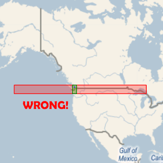
This is WRONG WRONG WRONG because Geoquery is not correctly rendering POLYGONs on the curvature of the Earth's surface... so you THINK they should intersect, but STIntersects() correctly returns false.

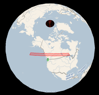
If we use LINESTRINGs to do the drawing (which Geoquery 2008 v0.7 DOES support) then it's rendered correctly and you can see that they don't overlap:
/* However converting to a LINESTRING which is rendered correctly, it's clear they don't intersect*/
DECLARE @myPoint geography, @polySmall geography, @polyBIG geography
SET @myPoint = geography::Parse('POINT(49.274138 -123.098562)')
SET @polySmall = geography::Parse('LINESTRING(47.0 -124.0, 47.0 -122.0, 50.0 -122.0, 50.0 -124.0, 47.0 -124.0)')
SET @polyBIG = geography::Parse('LINESTRING(47.0 -155.0, 47.0 -85.0, 50.0 -85.0, 50.0 -155.0, 47.0 -155.0)')
SELECT @polySmall, 'Green' as Color, '#4400ff00' as fill
SELECT @polyBIG, 'Red' as Color, '#44ff0000' as fill
SELECT @myPoint, 'Blue' as Color, 2 as Thickness


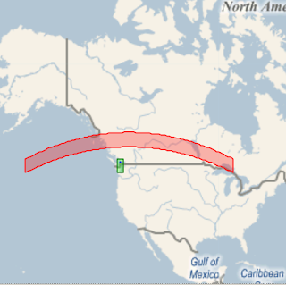
Even more interesting - the lines that should be parallel ARE, and the lines that shouldn't be (longitude) AREN'T, when drawn on a globe (as they should be).


p.s. if you're wondering why LINESTRING works and POLYGON doesn't; it was (fairly) trivial to handle lines that 'break' over the +/-180 longitude (~international date line), but less so to 'split' POLYGONs into parts to draw independently ... so I left it out (for now). Sorry 'bout that.

UPDATE 31-Jan: this has been fixed and Geoquery 2008 v0.71 is available for download

Tuesday, 29 January 2008

Geoquery 2008 v0.7 (beta) available for "testing"

The latest version of Geoquery, v0.7, is available for download. Unfortunately it was a bit of a rush to get it out, so I haven't updated all the instructions - hopefully you'll get the hang of it.

Obligatory screenshot:

Monday, 28 January 2008

STIntersects=true; STIntersection=null ??

Not really sure whether this is a 'bug' or me not just 'getting' the single-hemisphere restriction, but sometimes when STIntersects returns true, STIntersection returns null.

I first noticed it when 'drawing' LINESTRINGs across the 'international date line' (longitude=180) which is where the default map edges are -- the "line" from Sydney to Los Angeles necessarily crosses this boundary.
DECLARE @idl geography
DECLARE @idlSouth geography
DECLARE @SYDtoEquator geography
DECLARE @SYDtoLAX geography

SET @idl = geography::STGeomFromText('LINESTRING(85 180, -85 180)',4326);
SET @idlSouth = geography::STGeomFromText('LINESTRING(0 180, -85 180)',4326);
SET @SYDtoEquator = geography::STGeomFromText('LINESTRING(-33.9 151.12, 0 -118.4)', 4326);
SET @SYDtoLAX = geography::STGeomFromText('LINESTRING(-33.9 151.12, 33.8 -118.4)', 4326);

SELECT @SYDtoEquator.STIntersects(@idl) as [Intersects]
, @SYDtoEquator.STIntersection(@idl) as [Intersection]
, @SYDtoEquator, 'Sydney to Equator' as [Desc]
, 'why is Intersection null?' as [Question]
SELECT @SYDtoLAX.STIntersects(@idl) as [Intersects]
, @SYDtoLAX.STIntersection(@idl) as [Intersection]
, @SYDtoLAX , 'Sydney to LAX' as [Desc]
/* shortening the 'idl' line 'fixes' it */
SELECT @SYDtoEquator.STIntersects(@idlSouth) as [Intersects]
, @SYDtoEquator.STIntersection(@idlSouth ) as [Intersection]
, @SYDtoEquator, 'Sydney to Equator' as [Desc]
SELECT @SYDtoLAX.STIntersects(@idlSouth) as [Intersects]
, @SYDtoLAX.STIntersection(@idlSouth) as [Intersection]
, @SYDtoLAX, 'Sydney to LAX' as [Desc]
This is the result "set"


And this is how the lines "should look"


As the line endpoint changes, so does the STIntersection result (although STIntersects returns true every time)
@SYDtoEquator = geography::STGeomFromText
('LINESTRING(-33.9 151.12, 10 -118.4)', 4326); -- NULL
@SYDtoEquator = geography::STGeomFromText
('LINESTRING(-33.9 151.12, 20 -118.4)', 4326); -- NULL
@SYDtoEquator = geography::STGeomFromText
('LINESTRING(-33.9 151.12, 30 -118.4)', 4326); -- GOOD
@SYDtoEquator = geography::STGeomFromText
('LINESTRING(-33.9 151.12, 40 -118.4)', 4326); -- GOOD
@SYDtoEquator = geography::STGeomFromText
('LINESTRING(-33.9 151.12, 50 -118.4)', 4326); -- NULL

So... any thoughts why some of these 'succeed' while others fail?

Thursday, 24 January 2008

Spatial queries: not just for Earth

No idea what real applications this might have, but it was kinda fun:
/* http://www.fi.edu/pieces/schutte/landchart.html */
select -- Apollo landings
geography::STGeomFromText('POINT(0.67 23.49)', 4326)--1
, geography::STGeomFromText('POINT(-2.94 -23.45)', 4326)--2
, geography::STGeomFromText('POINT(-3.67 -17.46)', 4326)--14
, geography::STGeomFromText('POINT(26.11 3.66)', 4326)--15
, geography::STGeomFromText('POINT(-8.6 15.31)', 4326)--16
, geography::STGeomFromText('POINT(20.17 30.8)', 4326)--17
, 15.0 AS [Thickness], '#770000ff' AS [Color]


The map data in Geoquery is in a configurable Xml file - MapSources.xml so it's relatively simple to include different tile servers for Earth images (as well as the Moon & Mars)!

Friday, 18 January 2008

geography:STBuffer() IS 'straight'

It can be difficult to visualize "geographic" straight lines (intersections, overlaps, etc) on a 'flat' projection, so here's a set of STBuffers over the LAX-JFK line... it doesn't "look" straight until you see it on a globe:


Using the 'special columns' feature of Geoquery (and a different map...)
DECLARE @g GEOGRAPHY
SET @g = geography::STGeomFromText('LINESTRING(33 -118, 40 -73)', 4326);
SELECT @g, 'Blue' AS [COLOR], 2 AS [Thickness]
UNION ALL SELECT @g.STBuffer(450000), 'Blue' as [COLOR], 1 AS [Thickness]
UNION ALL SELECT @g.STBuffer(1500000), 'Green' as [COLOR], 1 AS [Thickness]
UNION ALL SELECT @g.STBuffer(3000000), 'Purple' as [COLOR], 1 AS [Thickness]
UNION ALL SELECT @g.STBuffer(4000000), 'Orange' as [COLOR], 1 AS [Thickness]

Thursday, 17 January 2008

Geoquery: when a straight line isn't straight...

I was already aware that straight lines on a sphere (aren't really straight), but had left the correct handling of such matters out of Geoquery 0.6.

Unfortunately, this made it look rather incomplete; simply drawing a straight line over a projected map...

...isn't quite right

There are quite a few references for how to calculate the 'correct line' - I liked Ed Williams Aviation Formulary - and finally got around to giving it a try.

Here is how the query (and result) should look; with a couple of extra STBuffers thrown in...
DECLARE @g geography;
-- LAX 33°57 -118°24
-- JFK 40°38 -73°47

SET @g = geography::STGeomFromText(
'LINESTRING(33 -118, 40 -73)', 4326);
SELECT @g, null,null,null, 'Blue' as [COLOR]
UNION ALL
SELECT @g.STBuffer(450000), @g.STBuffer(1500000), @g.STBuffer(3000000), @g.STBuffer(4000000), 'Orange' as [COLOR]


The interesting thing about this canvas is the 'straight line' was the only element that I needed to programmatically 'project' -- Katmai's spatial support in the GEOGRAPHY::STBuffer() result is already a POLYGON whose points can be applied directly to the map-projection (ie. it isn't just described as two semicircular shapes joined by two parallel straight lines).

Geoquery can also correctly show buffers on points [aren't] circular on a projected map; the query from that link is reproduced below

DECLARE @g geography;
-- Copenhagen 55°37 12°39
SET @g = geography::STGeomFromText('POINT(55.55 12.66)', 4326);
SELECT @g, 'Blue' as [COLOR]
UNION ALL
SELECT @g.STBuffer(4000000), 'Purple' as [COLOR]


NOTE: Geoquery 2008 0.7 (which contains the enhancements described above) is NOT YET AVAILABLE for download. When it is available, it will also include the complete set of GEOGRAPHY Examples in addition to the GEOMETRY ones already available.

Wednesday, 16 January 2008

Geoquery 2008 v0.6 (beta)

Geoquery 2008 now supports the GEOGRAPHY datatype as well - displaying the results on a Virtual Earth map rather than a white shape canvas.


v0.6 also adds an Export... function so you can save spatial query results graphically, for emailing/reports/etc.


Here are a couple of Exported resultsets from the MSDN Sample queries...

Wednesday, 9 January 2008

Geoquery: Geography MkII

Just displaying a series of points doesn't look like much


but it can be the foundation of some neat spatial reporting - this query (attempts to) show the density of votes by postcode.

select p.postcode, p.location,
CASE
WHEN p.Postcode < 2000 THEN '#44ff0000'
WHEN p.Postcode < 3000 THEN '#4400ff00'
WHEN p.Postcode < 4000 THEN '#440000ff'
WHEN p.Postcode < 5000 THEN '#44880088'
WHEN p.Postcode < 7000 THEN '#44FFFF00'
END AS [Color]
, CASE WHEN Totalvotes < 1000 THEN 1
WHEN Totalvotes < 2000 THEN 2
WHEN Totalvotes < 3000 THEN 3
WHEN Totalvotes < 4000 THEN 4
WHEN Totalvotes < 5000 THEN 5
ELSE 6 END AS [Thickness]
from Postcodes P
INNER JOIN PollingPlaces pp ON pp.Postcode = p.Postcode
INNER JOIN PollingPlaceVotes ppv ON ppv.PollingPlaceID = pp.PollingPlaceID


Note the status bar - that's 56,951 rows!! Try loading those points into Virtual Earth! :-)

Sunday, 6 January 2008

Geoquery is learning maps


Turns out basic 'map' support was pretty easy (although it's not quite done and available for download just yet...)

This article came in handy - Virtual Earth Tile System - I'd previously used it as a reference for SilverlightEarth.com, although I had to convert it to jscript for that.

Thursday, 27 December 2007

SQL Server 2008 Geography: STExteriorRing, STInteriorRingN

MSDN describes STExteriorRing() with this query
DECLARE @g geometry;
SET @g = geometry::STGeomFromText('POLYGON((0 0, 3 0, 3 3, 0 3, 0 0),(2 2, 2 1, 1 1, 1 2, 2 2))', 0);
SELECT @g.STExteriorRing().ToString();

which returns
LINESTRING (0 0, 3 0, 3 3, 0 0, 0 0)

Here it is visually -- the Green line is the original geometry (one square inside another), the thicker Blue line shows that STExteriorRing and the Orange line shows STInteriorRing(1):
DECLARE @g geometry;
SET @g = geometry::STGeomFromText('POLYGON((0 0, 3 0, 3 3, 0 3, 0 0),(2 2, 2 1, 1 1, 1 2, 2 2))', 0);
SELECT @g.STExteriorRing(), 0.3 as thickness, 'Blue' as color
UNION ALL
SELECT @g.STInteriorRingN(1), 0.2 as thickness, 'Orange' as color
UNION ALL
SELECT @g, 0.1 as thickness, 'Green' as color


Interestingly, this query exposed a bug in Geoquery where the Exterior and Interior rings were being 'joined' (ie there was no "pen up" occuring as the shapes were generated) -- causing the dodgy looking lines on the world map in the last post. Here's the "fixed" map drawing...

SQL Server 2008 Geometry: STUnion Aggregate

There doesn't seem to be a lot of information about Geometry Aggregates, except for these posts on MSDN Forums, including How to calculate table all geometry extent?

Why might we want aggregate functions on the GEOMETRY spatial datatype? Here's an example of 'how to use' the STUnion() from MSDN:
DECLARE @g geometry;
DECLARE @h geometry;
SET @g = geometry::STGeomFromText('POLYGON((0 0, 0 2, 2 2, 2 0, 0 0))', 0);
SET @h = geometry::STGeomFromText('POLYGON((1 1, 3 1, 3 3, 1 3, 1 1))', 0);
SELECT @g.STUnion(@h) -- Can only STUnion two Geometries
On the left are the two GEOMETRYs, on the right is the STUnion() result.


The problem with these simple examples is they don't scale well to 'real' spatial database queries where you need to use these functions across result-sets. For example, it would be much nicer if we could insert data as follows

INSERT INTO TestShapes VALUES (geometry::STGeomFromText('POLYGON((0 0, 0 2, 2 2, 2 0, 0 0))', 0))
INSERT INTO TestShapes VALUES (geometry::STGeomFromText('POLYGON((1 1, 3 1, 3 3, 1 3, 1 1))', 0))
-- Now 'Union' all the shapes
SELECT dbo.UnionAggregate(Shape) FROM TestShapes


On the left is the result of this new UnionAggregate query, on the left is the result after added another shape;
INSERT INTO TestShapes VALUES (geometry::STGeomFromText('POLYGON((3 3, 5 3, 5 5, 3 5, 3 3))', 0))
SELECT dbo.UnionAggregate(Shape) FROM TestShapes


DOWNLOAD the source (8k) to try out the two aggregates posted on MSDN, or follow these steps:

1. Download the code from MSDN, or my copy. NOTE: You must do all these steps on a PC with SQL Server 2008 (Katmai) installed to get the Microsoft.SqlServer.Types.dll assembly. I copied this assembly into C:\assemblies\.

2. Compile the C# SQLCLR functions in C:\assemblies\ via the Command Prompt
c:\windows\microsoft.net\framework\v3.5\csc /t:library /r:Microsoft.SqlServer.Types.dll C:\assemblies\aggregate.cs

3. Execute T-SQL to register the aggregate functions in SQL Server 2008
CREATE ASSEMBLY SpatialAggregate FROM 'c:\assemblies\Aggregate.dll'
go
CREATE AGGREGATE EnvelopeAggregate(@input GEOMETRY) RETURNS GEOMETRY
external name [SpatialAggregate].[SilverlightEarth.Geoquery.SqlClr.EnvelopeAggregate]
go
CREATE AGGREGATE UnionAggregate(@input GEOMETRY) RETURNS GEOMETRY
external name [SpatialAggregate].[SilverlightEarth.Geoquery.SqlClr.UnionAggregate]
go

sp_configure 'clr enabled', 1;
go
RECONFIGURE;
go


Here's another example of using the STUnion Aggregate, this time to outline continents on a GEOMETRY map. Note the thickness and color columns are a feature of Geoquery.

select continent, dbo.UnionAggregate(Location), 0.5 as thickness, 'Brown' as color
from countries2 where continent is not null and Location.STArea() > 40
group by continent
union all
select name, Location, 0.1 as thickness, 'Green' as color
from countries2


(Not sure why weird lines appear through some of the STUnion-ed geometries... something to investigate another day)

Wednesday, 19 December 2007

SQL Server 2008 Geometry: Reduce

I once had a go at using the Douglas-Peucker Algorithm in C# (for RaceReplay.net), so it was interesting to see it "pop-up" in SQL Server 2008 as the Reduce() function.

To understand what it does, you could try these queries (using country polygon data from the Google Earth community):

-- Tasmania from kmz
DECLARE @a GEOMETRY
SET @a = geometry::STGeomFromText('POLYGON((146.5861 41.18666, 147.9718 40.74479, 148.2733 40.90111, 148.3638 42.22243, 148.1953 41.94545, 148.0791 42.11722, 147.8429 42.87292, 147.9997 42.90708, 147.9955 43.22759, 147.7897 43.24695, 147.6316 43.06555, 147.7065 42.93833, 147.8994 43.02687, 147.8258 42.93195, 147.5575 42.83056, 147.4271 43.04174, 147.3175 42.84666, 147.2475 43.26917, 146.9913 43.11243, 147.0953 43.28872, 146.8336 43.64806, 146.0383 43.49805, 145.9327 43.37632, 146.2345 43.32514, 145.8369 43.29723, 145.4597 42.90444, 145.2052 42.25695, 145.4694 42.52306, 145.552 42.35111, 144.8586 41.54445, 144.6372 41.03194, 144.7014 40.75917000000001, 146.5861 41.18666))',0)

SELECT @a.STNumPoints() AS [PointsInRawPolygon]
, @a.Reduce(0.2).STNumPoints() AS [PointsReduce1]
, @a.Reduce(1).STNumPoints() AS [PointsReduce5]


But it would be even better if we could visualize the effects that Reduce() has on the polygon data... introducing Geoquery Analyzer

Polygon data without Reduce()


Polygon data with moderate Reduce() tolerance


Polygon data with agressive Reduce() tolerance


Polygon data with overly agressive Reduce() tolerance!


And of course, if you raise the tolerance too high,
System.AgumentException: 24127: Using Reduce with the specified tolerance will yield an instance that is not valid. Using a smaller tolerance may achieve a valid result.


A few additional examples - some countries missing purely because the KML import had some errors...


NOTE 1: Geoquery Analyzer is currently in PRE alpha development status (ie. it's pretty dodgy). If/when the code gets to a fairly stable/usable point, it'll be uploaded here.

NOTE 2: if you looked really closely at the coordinates, you'll see I've changed the latitude values to be positive... the reason is NOTE 1.

NOTE 3: on the world maps, the 0,0 point is top/left which makes it appear upsidedown

Saturday, 15 December 2007

Battleship 2008 - GEOMETRY datatype sample

Here's a quick example of the new coordinate datatypes in SQL Server 2008, in the form of a game!

Battleship 2008 - GEOMETRY datatype and spatial functions in SQL Server (and on CodeProject) uses the basics - POINT and LINESTRING - to build a simple, single-player version of the game Battleship

This is what a game "looks like" (13 is the GameId, 4 is my PlayerId... the other numbers are the co-ordinates I'm shooting at)

it's played in Management Studio, like a 'command line', so you'll need to keep your own copy of the board on paper (like this?)


Enjoy!

Thursday, 13 December 2007

SQL Server 2008 Geography vs Geometry

Really basic comparison of GEOGRAPHY and GEOMETRY data types in SQL Server 2008.

First, some queries:
DECLARE @ll geography;
DECLARE @g geometry;

PRINT 'LatLong polygon length'
SET @ll = geography::STGeomFromText(
'POLYGON((1 1,1 5,5 5,5 1,1 1))', 4326);
SELECT @ll.STLength() -- 1773426.60585491

PRINT 'Geometry polygon length'
SET @g = geometry::STGeomFromText(
'POLYGON((1 1,1 5,5 5,5 1,1 1))', 4326);
SELECT @g.STLength() -- 16

PRINT 'LatLong polygon area'
SET @ll = geography::STGeomFromText(
'POLYGON((3 3,6 4,6 2,3 3))', 4326);
SELECT @ll.STArea() -- 36749145501.1338

PRINT 'Geometry polygon area'
SET @g = geometry::STGeomFromText(
'POLYGON((3 3,6 4,6 2,3 3))', 4326);
SELECT @g.STArea() -- 3


You might want to read this excellent explanation of the 'Each geography instance must fit inside a single hemisphere. A common reason for this error is that a polygon has the wrong ring orientation.' requirement before looking at the next query.

PRINT 'Ring-orientation: counterclockwise'
DECLARE @ll geography;
SET @ll = geography::STGeomFromText('POLYGON((3 3,6 4,6 2,3 3))', 4326);
-- Command(s) completed successfully.
SET @ll = geography::STGeomFromText('POLYGON((3 3,6 2,6 4,3 3))', 4326);
-- The specified input does not represent a valid geography instance because it exceeds a single hemisphere.


Make sense? Maybe this diagram will help (green, anti-clockwise arrows good; red, clockwise arrows bad)


The first attempt at MUTLIPOLYGON didn't work, and at first I couldn't understand why. I got this example WKT from Wikipedia:
DECLARE @ll geography;
SET @ll = geography::STGeomFromText(
'MULTIPOLYGON(((1 1,5 1,5 5,1 5,1 1),(2 2, 3 2, 3 3, 2 3,2 2)),((3 3,6 2,6 4,3 3)))'
, 4326);
-- The specified input does not represent a valid geography instance.

Here it is 'on paper'

you'll notice they overlap and are all described clockwise... no problem, right? After all, the example came from Wikipedia! Hmmm, the Reduce doco just happens to mention for example, an invalid MultiPolygon instance is created if Reduce() is applied to simplify each ring in the instance and the resulting rings overlap..

Ah ha! So SQL Server doesn't like overlapping elements within a MULTIPOLYGON? Let's try removing the 'overlaps' (making the green polygon smaller) like this:
DECLARE @l1 geography;
SET @l1 = geography::STGeomFromText(
'MULTIPOLYGON(((2 2, 2 3, 3 3, 3 2, 2 2)
,(3 3,6 4,6 2,3 3))
,((1 1,2 1,2 2,1 2,1 1)))'
, 4326);
-- The specified input does not represent a valid geography instance


Still not working - hmm, maybe the ring-orientation is also a problem?

DECLARE @l1 geography;
SET @l1 = geography::STGeomFromText(
'MULTIPOLYGON(((2 2, 2 3, 3 3, 3 2, 2 2)
,(3 3,6 4,6 2,3 3))
,((1 1,1 2,2 2,2 1,1 1)))'

, 4326); -- IT WORKS!


Interestingly, as long one of the POLYGONs is anti-clockwise, the query seems to work! Also interestingly, the previous query works using the GEOMETRY type (just to prove that the 'hemisphere problem' only applies to GEOGRAPHY!).

DECLARE @l1 geometry;
SET @l1 = geometry::STGeomFromText(
'MULTIPOLYGON(((2 2, 2 3, 3 3, 3 2, 2 2)
,(3 3,6 4,6 2,3 3))
,((1 1,2 1,2 2,1 2,1 1)))'
, 4326);
-- WORKS FOR GEOMETRY


Finally, here's another MULITPOLYGON example
DECLARE @ll geography;
SET @ll = geography::STGeomFromText(
'MULTIPOLYGON ((
(35.003075386599093 136.49999931072208,
35.004100499758216 136.00000001975212,
35.000000005283141 136.00000001974058,
35.003075386599093 136.49999931072208)),
((34.999999973649494 138.00000000826108,
36.5 136,
35.761206832024406 136.00000002190484,
35.004100371491738 136.99469190018391,
34.999999973649494 138.00000000826108)))'

, 4326);

SELECT @ll.STLength() -- 634673.083368519
SELECT @ll.STArea() -- 11370068204.2658
SELECT @ll.STIntersects(geography::STGeomFromText('POINT(-30.041 153.166)',4326)) -- 0
SELECT @ll.STIntersects(geography::STGeomFromText('POINT(36.5 136)',4326)) -- 1


Here's the query that confirms they don't overlap and therefore make a valid MULTIPOLYGON:
DECLARE @l1 geography;
DECLARE @l2 geography;
SET @l1 = geography::STGeomFromText('POLYGON ((
35.003075386599093 136.49999931072208,
35.004100499758216 136.00000001975212,
35.000000005283141 136.00000001974058,
35.003075386599093 136.49999931072208))'
, 4326);
SET @l2 = geography::STGeomFromText('POLYGON ((
34.999999973649494 138.00000000826108,
36.5 136,
35.761206832024406 136.00000002190484,
35.004100371491738 136.99469190018391,
34.999999973649494 138.00000000826108))'

, 4326);
SELECT @l1.STIntersects(@l2) -- 0 -- doesn't intersect!


That last example is from this post (in Japanese) on these Microsoft.SqlServer.Types. There is also a couple of excellent images that demonstrate the difference between GEOGRAPHY and GEOMETRY (remember to imagine the 2nd image is on a sphere!).