Showing posts with label database. Show all posts

Saturday, 11 July 2009

SQL in Silverlight

It never ceases to amaze me how short my attention span has become...

what was I saying :) ?

Aaanyway, I sat down in front of my PC today planning to accomplish a few different things... but before that I had to catch up on blogs and twitter. A tweet caught my eye
migueldeicaza IDEA: SOmeone to do a line-by-line port of Sqlite to C# to run inside Silverlight

"Great idea" I thought... but seemed like quite a big job and certainly not something I have the time to tackle. Then I started to recall seeing a C# port of an SQL engine (ages ago) and thought it might be fun to have a poke around. At least it would be easier to port something already in .NET land.

A couple of Google results later, I came across Sharp HSql, a circa 2001 port of the Java-based hsqldb (licence). The code was subsequently added to Codeplex with the following warning: This version is not ready for production grade applications. More testing is needed and some important bugs has to be fixed before that. You are warned.
Long story short...
it's a couple of hours later and I've done nothing that I'd planned to, but here is an 'alpha' of SharpHSql for Silverlight (try it out) - there's some test SQL at the bottom of the post.


The "port" mainly consisted of:
  • 'implementing' ArrayList and Hashtable (umm, can you say List<object> and Dictionary<object, object>)
  • removing the 'Provider' and all the dependencies on System.Data that work fine in the full framework, but are missing from Silverlight (would be nice to add some sort of wrapper back in...)
  • converting FileInfo and related operations to IsolatedStorageFileStream (still some persistence testing to do...)
  • breaking DateTime handling (for now)
The REAL work was all done by Mark Tutt so don't get the idea that I'm taking any credit - all the goodness is his, any errors are mine.

The full source of the consuming Silverlight app is this Page.xaml and Page.xaml.cs; the full Visual Studio 2008 project ZIP (199Kb) is available to download. Anywhere I've touched the code you'll find a //HACK: tag!

Disclaimer: I've no idea if this is fit for any purpose at all... it seems to be able to DROP and CREATE tables, INSERT rows and SELECT/JOIN - but even that could be a fluke. Try it out at your own risk; leave a comment if you find something good or bad. Have fun!

UPDATE: the output is a lot prettier (try it) with the Silverlight DataGrid and Vladimir Bodurov's awesome dynamic datasource compiler - updated for generic types

(updated source (277Kb))

Test SQL

#1
DROP TABLE IF EXIST "books";CREATE TABLE "books" ("id" INT NOT NULL PRIMARY KEY, "name" char, "author" char, "qty" int, "value" numeric);

INSERT INTO "books" VALUES (1, 'Book000', 'Amy', 1, 23.5);
INSERT INTO "books" VALUES (2, 'Book001', 'Andy', 2, 43.9);
INSERT INTO "books" VALUES (3, 'Book002', 'Andy', 3, 37.25);
INSERT INTO "books" VALUES (4, 'Book 21', 'Amy', 99, 20.5);
INSERT INTO "books" VALUES (5, 'Book 22', 'Andy', 2, 903.9);
INSERT INTO "books" VALUES (6, 'Book 23', 'Andy', 5, 0.25);

SELECT * FROM "books" ORDER BY "value"

DROP TABLE IF EXIST "author";CREATE TABLE "author" ("name" char NOT NULL PRIMARY KEY, "country" char);

INSERT INTO "Author" VALUES ('Andy', 'UK');
INSERT INTO "Author" VALUES ('Amy', 'USA');

SELECT * FROM "author" ORDER BY "value"

SELECT * FROM "books" LEFT JOIN "author" ON "author"."name" = "books"."name"
#2
CREATE TABLE "clients" ("id" int NOT NULL IDENTITY PRIMARY KEY, "DoubleValue" double, "nombre" char, "photo" varbinary, "created" date );
INSERT INTO "clients" ("DoubleValue", "nombre", "photo", "created") VALUES (1.1, 'NOMBRE')
SELECT * FROM "clients"

Monday, 6 April 2009

*.MDF' cannot be opened because it is version 655. This server supports version 612 and earlier

When I'm not playing with Silverlight and Virtual Earth, I've been figuring out MVC (thanks to Scott, Scott and Phil). However pretty early on I hit a weird error in Visual Studio 2008 when trying to 'open' a database via the Server Explorer:

The database 'C:\SOME\FOLDER\MYDATABASE.MDF' cannot be opened because it is version 655. This server supports version 612 and earlier. A downgrade path is not supported.

Background

I had created that database in Visual Studio 2008 (File → Add New Item → SQL Server Database) and now it wouldn't let me open it!

What I had done is opened, edited and closed the database file using SQL Server 2008 Management Studio. Shouldn't be a problem, right, since I'm also using Visual Studio 2008?

The Problem

Well, although I currently have SQL Server 2008 installed, I also have SQL Server 2005 (which was installed with Visual Studio 2008 originally). When I created the database originally I just assumed it was a SQL Server 2008 database - but it wasn't (it was 2005)!

Turns out that when you are create or open a file-based (.MDF) database (as opposed to using a database instance or server connection) Visual Studio needs some 'help' knowing what tools to use.

When I edited the *.MDF file in SQL Server 2008, it made some fundamental "changes" to the file (even though I didn't 'upgrade' it) which prevented SQL Server 2005 from opening it. Why was Visual Studio 2008 confused? It's a configuration setting!
To fix the problem, go to Tools → Options... → Database Tools → Data Connections and change the SQL Server Instance Name from whatever it was (probably a SQL Server 2005 instance) to your SQL Server 2008 instance, hit OK and you should be fine!


Thanks to simple-talk; and SQL 2008 Express edition error/Add new item on ASP.NET forms. A bit OT - HTH someone...

Friday, 3 April 2009

Script diagrams using SQL Server 2008

Originally this script was ScriptDiagram2005 (on CodeProject), based on a SQL Server 2000 version by Clay Beatty.


I had already tested the '2005' version on "Katmai" betas of SQL Server 2008 and it worked fine, so I hadn't bothered to update the script until I read
this thread (requires login) and learned of the built-in sys.fn_varbintohexstr function.

This made the previous custom function Tool_VarbinaryToVarcharHex redundant, so I have updated the code to ScriptDiagram2008. There isn't really any code to download - just view the script (copy/paste to an .SQL file to apply to your database).

Makes it easy to add your diagrams to source control - still figuring out how to fit it nicely into Visual Studio Team System Database Edition GDR...

Saturday, 24 January 2009

Calculating distance in C# (with SqlServer.Types)

WiredPrairie's post on Calculating the distance between two Zip Codes in C# starts with the line
Unfortunately, there are many classes built into the .NET framework, but a zip code distance calculator isn’t included.
which is true -- however with the release of SQL Server 2008 Microsoft has made available the redistributable Microsoft.SqlServer.Types assembly that contains the SqlGeography and SqlGeometry types. Within SQL Server 2008 this enables the new geospatial functions, but these types can also be used in C#. I thought I'd add the SQL Server types to his example, just for fun...

I've modified WiredPrairie's code to use Microsoft.SqlServer.Types.SqlGeography in place of manually calculating Radians and using the Haversine formula... only a few minor changes were required (view source):

0. Reference Microsoft.SqlServer.Types assembly


1. Replace the Distance() method completely
I haven't implemented miles here - just kilometres

The important bits being:
string lineString = String.Format("LINESTRING({0} {1}, {2} {3})"
, compare.Longitude, compare.Latitude
, this.Longitude, this.Latitude);
var g = Microsoft.SqlServer.Types.SqlGeography.STGeomFromText(
new System.Data.SqlTypes.SqlChars(new System.Data.SqlTypes.SqlString(
lineString
))
, 4326); // IMPORTANT for distance calc
geoDistance = Convert.ToDouble(g.STLength().ToString()) / 1000; // to kilometers

2. Remove the conversion to Radians
The SqlGeography type uses Latitude and Longitude in degrees.


3. Minor text changes (miles to kilometres)


4. and finally, change the input from '25 miles' to '40 kilometres'
Here is a comparison of the results -- there appears to minor differences in the calculation results - I assume due to rounding...


Of course, WiredPrairie's solution would run anywhere (including Silverlight) whereas adding a dependency to Microsoft.SqlServer.Types means you can only use this code where the SqlServer Types redistributable has been installed. It's still interesting to see the additional features provided by SQL Server 2008 - I hope some spatial types (without the SQL dependency) make their way into a future core .NET Framework release (and Silverlight 3.0??).

Tuesday, 7 October 2008

Design wireframes/black&whites/whatever in Flash

I saw Tim's post on Software Mockups using Balsamiq just a few days after independently 'discovering' it via Russ.

I'm a big fan of 'visuals', so I had to immediately give it a try, mocking up some additions to Geoquery 2008's user interface:

I think a 'google earth globe' is about the only widget they didn't include!

Balsamiq Mockups is great fun - a very wide variety of widgets are built in, the Flash interface is easy to use (and if you can't get stuff to quite line up exactly, who cares! it's a mockup!). If you continue to use it, don't forget to buy.

Wednesday, 27 August 2008

GeoData Visualization: Geoquery v. SQL Server 2008

Came across this post today - GeoData Visualization vs. Analysis - and thought it would be fun to try in Geoquery.

The dataset (au_sumg.e00) can be found at USGS and imported into SQL Server 2008 using Shape2Sql (by Morten). Among other statistics it contains data on known oil reserves (outside the USA, as of 2000).

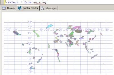
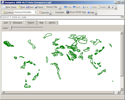
The simplest query - SELECT * FROM au_sumg - looks like this in SQL Server 2008 Management Studio and Geoquery 2008 respectively:


Management Studio's Dundas graphic sure looks nice - but a little difficult to interpret in isolation. Geoquery's Shape tab looks worse without even the funky pastel colors.

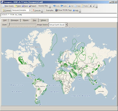
However, the Map tab in Geoquery starts to make up for the green-ness by giving the shapes some context.


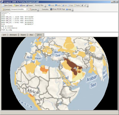
But that's not all - using the same 'scale' as this image and the [Fill] and [Thickness] 'special columns' that Geoquery supports we can write this:
select * ,
CASE
WHEN KWN_OIL < -6238 THEN '#FFF2ECB0'
WHEN KWN_OIL < 15769 THEN '#FFF3CE75'
WHEN KWN_OIL < 37775 THEN '#FFEA944B'
WHEN KWN_OIL < 59781 THEN '#FFB16B3A'
ELSE '#FF864E37'
END AS [Fill]
, 0 AS [Thickness]
FROM au_sumg
to produce this result:


Of course, viewing these results on the globe offers absolutely no advantage; but I'll include an obligatory screenshot anyway...

Wednesday, 20 August 2008

Geoquery 2008 v0.73 (for SQL Server 2008 RTM)

v0.72 of Geoquery2008 has been recompiled against Microsoft.NET Framework 3.5 SP1 and updated for the RTM of SQL Server 2008. It also has a new home, at

Geoquery2008.com!

It is now aware of the geography coordinate order swap and only requires the Client Profile portion of Microsoft.NET Framework 3.5 Service Pack 1 and the System CLR Types to run.

The next 'major' version - 0.8 - is still a work-in-progress - but will never be designed to compete with the 'built-in' Spatial Results Tab in Management Studio.

Thursday, 15 May 2008

Whither Geoquery?

If you were reading this blog earlier in the year, you may have seen these posts on Geoquery for SQL Server 2008.

Since my last post (in March) a few things have happened to stall development:
1) Running. I was injured over summer (that's Dec-Feb down here) and couldn't train - all that extra free time went into developing Geoquery. Now I'm back in training.
2) Holidays. Spent a few weeks in Thailand and Bhutan.
3) Job. It's busier now.
4) I was using the demo version Visual Studio 2008. It's expired. The Express versions just don't cut it for "real" work.
5) I can't help thinking Microsoft is going to release something similar themselves. It was great fun building it up to v0.72, but now real hard work is required to get the functionality "to the next level". That's a lot of effort for "nothing", less fun and more sweat.

I saw today that Google Maps now has a Flash API (and demos), something Yahoo has had for a while. I might get back to playing with silverlightearth.com and deepzoompublisher.com in Silverlight 2.0.

There may yet be a way to tie them all together: converting silverlightearth.com to Silverlight 2.0 will result in a whole pile of C# and Xaml that would then plug right into Geoquery 2008. Will see how things develop... ;-)

Tuesday, 4 March 2008

Geoquery 2008 v0.72

Another minor release of Geoquery 2008 to finish off some of the 'known bugs' around line and polygon rendering... It can be downloaded here.

First up, Morten has helped fix a number of bugs in Geoquery, and this release is no exception. While trying out his OGC conformance test map I discovered some GEOMETRY idiosyncrasies I still hadn't fixed. If you read his post and download the schema/data, this sql works best in Geoquery.


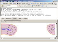
Morten also pointed out the issue with holes... (notice how the GEOGRAPHY instance is rendered on both the Shape & Map tabs!)


And finally, after a month away from the code (some of it at the beach :) it was relatively quick to solve most of the problems around 'wrapping': with a bit more help from Ed Williams I was able to discard my previous efforts (using the SqlTypes) and solve the problem with some basic math - hoorah!


I expect it will be a bit of a wait for the next version of this code. I have a lot of ideas to incorporate, some of which require further architectural changes. I will also update the Examples to discuss the new features in CTP6. Until then - enjoy Geoquerying...

Monday, 3 March 2008

Back to "work" on Geoquery

After a great holiday at the beach, a rushed implementation of PayPal, some silverlight prototyping and fighting with IL at work, I've finally found some time to work on Geoquery again.

v0.8 is pretty ambitious, so it's likely to be an interim version that fixes a few more bugs, such as polygons that cross +/- 180 degrees Longitude.


and Geography displayed on the Shapes tab


and the dodgy example from my last post


Still a little more to do (what about when the polygon disappears above +/-85 degrees Latitude), but hopefully I'll be back working on street-level maps 'any time now'.


p.s. yeah, I went to the "2008 launch wave". What I don't get is when headlines that look like {data binding} became cool marketing?

Thursday, 31 January 2008

Geoquery 2008 v0.71 (oops)

Geoquery 0.7 has been quickly updated to 0.71 to fix the bug from yesterday.

It was while I was describing the problem that I was reminded how confusing it is for users when something "fails silently".

Imagine if the a "File-Save" function didn't report an error when your latest masterpiece couldn't be saved... you'd close the application and expect the data to be available next time - but it would be gone... forever! I strongly discourage rampant use of try{}catch{} in C# because it often (inadvertently) leads to silent failures.

By drawing the polygons on the Map & Sphere, but drawing them incorrectly, Geoquery was giving the impression that it was working when it wasn't. OK, probably not as severe as losing a file, but confusing nevertheless. It seemed important enough to fix and update (even though just a day earlier I'd decided it was "good enough for now").

So now the polygons are drawn correctly, and when they can't be (across +/-180° longitude), it "fails loudly" :)
SELECT geography::STGeomFromText(
'POLYGON((-33.9 151.12, 0 -118.4, 33.8 -118.4,-33.9 151.12))', 4326
), 'Red' as color, '#33ff0000' as Fill


P.S. a couple of other issues were also fixed, thanks Morten!

Wednesday, 30 January 2008

Geoquery 2008 beta - polygons on sphere NOT!

The releast notes for the latest Geoquery beta release should state in BIG BOLD LETTERS that the POLYGON GEOGRAPHY is not correctly rendered. I knew this but rushed the release out regardless - but this MSDN Forums post reminded me how confusing this can be so I wanted to be sure people use LINESTRING for now.

To illustrate, the poster wants to know why these polygons don't BOTH STIntersect 'Vancouver'...
DECLARE @myPoint geography, @polySmall geography, @polyBIG geography
SET @myPoint = geography::Parse('POINT(49.274138 -123.098562)')
SET @polySmall = geography::Parse('POLYGON((47.0 -124.0, 47.0 -122.0, 50.0 -122.0, 50.0 -124.0, 47.0 -124.0))')
SET @polyBIG = geography::Parse('POLYGON((47.0 -155.0, 47.0 -85.0, 50.0 -85.0, 50.0 -155.0, 47.0 -155.0))')
SELECT @polySmall.STIntersects(@myPoint) AS Intersect_polySmall, @polyBIG.STIntersects(@myPoint) AS Intersect_polyBIG
SELECT @polyBIG , 'Red' as Color, '#44ff0000' as fill
SELECT @polySmall, 'Green' as Color, '#4400ff00' as fill
SELECT @myPoint, 'Blue' as Color, 2 as Thickness
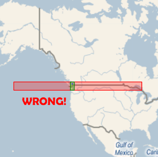
because he's visualizing the shapes looking like this:

This is WRONG WRONG WRONG because Geoquery is not correctly rendering POLYGONs on the curvature of the Earth's surface... so you THINK they should intersect, but STIntersects() correctly returns false.

If we use LINESTRINGs to do the drawing (which Geoquery 2008 v0.7 DOES support) then it's rendered correctly and you can see that they don't overlap:
/* However converting to a LINESTRING which is rendered correctly, it's clear they don't intersect*/
DECLARE @myPoint geography, @polySmall geography, @polyBIG geography
SET @myPoint = geography::Parse('POINT(49.274138 -123.098562)')
SET @polySmall = geography::Parse('LINESTRING(47.0 -124.0, 47.0 -122.0, 50.0 -122.0, 50.0 -124.0, 47.0 -124.0)')
SET @polyBIG = geography::Parse('LINESTRING(47.0 -155.0, 47.0 -85.0, 50.0 -85.0, 50.0 -155.0, 47.0 -155.0)')
SELECT @polySmall, 'Green' as Color, '#4400ff00' as fill
SELECT @polyBIG, 'Red' as Color, '#44ff0000' as fill
SELECT @myPoint, 'Blue' as Color, 2 as Thickness


Even more interesting - the lines that should be parallel ARE, and the lines that shouldn't be (longitude) AREN'T, when drawn on a globe (as they should be).


p.s. if you're wondering why LINESTRING works and POLYGON doesn't; it was (fairly) trivial to handle lines that 'break' over the +/-180 longitude (~international date line), but less so to 'split' POLYGONs into parts to draw independently ... so I left it out (for now). Sorry 'bout that.

UPDATE 31-Jan: this has been fixed and Geoquery 2008 v0.71 is available for download

Tuesday, 29 January 2008

Geoquery 2008 v0.7 (beta) available for "testing"

The latest version of Geoquery, v0.7, is available for download. Unfortunately it was a bit of a rush to get it out, so I haven't updated all the instructions - hopefully you'll get the hang of it.

Obligatory screenshot:

Monday, 28 January 2008

STIntersects=true; STIntersection=null ??

Not really sure whether this is a 'bug' or me not just 'getting' the single-hemisphere restriction, but sometimes when STIntersects returns true, STIntersection returns null.

I first noticed it when 'drawing' LINESTRINGs across the 'international date line' (longitude=180) which is where the default map edges are -- the "line" from Sydney to Los Angeles necessarily crosses this boundary.
DECLARE @idl geography
DECLARE @idlSouth geography
DECLARE @SYDtoEquator geography
DECLARE @SYDtoLAX geography

SET @idl = geography::STGeomFromText('LINESTRING(85 180, -85 180)',4326);
SET @idlSouth = geography::STGeomFromText('LINESTRING(0 180, -85 180)',4326);
SET @SYDtoEquator = geography::STGeomFromText('LINESTRING(-33.9 151.12, 0 -118.4)', 4326);
SET @SYDtoLAX = geography::STGeomFromText('LINESTRING(-33.9 151.12, 33.8 -118.4)', 4326);

SELECT @SYDtoEquator.STIntersects(@idl) as [Intersects]
, @SYDtoEquator.STIntersection(@idl) as [Intersection]
, @SYDtoEquator, 'Sydney to Equator' as [Desc]
, 'why is Intersection null?' as [Question]
SELECT @SYDtoLAX.STIntersects(@idl) as [Intersects]
, @SYDtoLAX.STIntersection(@idl) as [Intersection]
, @SYDtoLAX , 'Sydney to LAX' as [Desc]
/* shortening the 'idl' line 'fixes' it */
SELECT @SYDtoEquator.STIntersects(@idlSouth) as [Intersects]
, @SYDtoEquator.STIntersection(@idlSouth ) as [Intersection]
, @SYDtoEquator, 'Sydney to Equator' as [Desc]
SELECT @SYDtoLAX.STIntersects(@idlSouth) as [Intersects]
, @SYDtoLAX.STIntersection(@idlSouth) as [Intersection]
, @SYDtoLAX, 'Sydney to LAX' as [Desc]
This is the result "set"


And this is how the lines "should look"


As the line endpoint changes, so does the STIntersection result (although STIntersects returns true every time)
@SYDtoEquator = geography::STGeomFromText
('LINESTRING(-33.9 151.12, 10 -118.4)', 4326); -- NULL
@SYDtoEquator = geography::STGeomFromText
('LINESTRING(-33.9 151.12, 20 -118.4)', 4326); -- NULL
@SYDtoEquator = geography::STGeomFromText
('LINESTRING(-33.9 151.12, 30 -118.4)', 4326); -- GOOD
@SYDtoEquator = geography::STGeomFromText
('LINESTRING(-33.9 151.12, 40 -118.4)', 4326); -- GOOD
@SYDtoEquator = geography::STGeomFromText
('LINESTRING(-33.9 151.12, 50 -118.4)', 4326); -- NULL

So... any thoughts why some of these 'succeed' while others fail?

Thursday, 24 January 2008

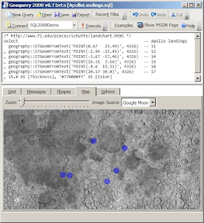
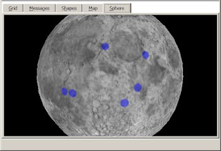
Spatial queries: not just for Earth

No idea what real applications this might have, but it was kinda fun:
/* http://www.fi.edu/pieces/schutte/landchart.html */
select -- Apollo landings
geography::STGeomFromText('POINT(0.67 23.49)', 4326)--1
, geography::STGeomFromText('POINT(-2.94 -23.45)', 4326)--2
, geography::STGeomFromText('POINT(-3.67 -17.46)', 4326)--14
, geography::STGeomFromText('POINT(26.11 3.66)', 4326)--15
, geography::STGeomFromText('POINT(-8.6 15.31)', 4326)--16
, geography::STGeomFromText('POINT(20.17 30.8)', 4326)--17
, 15.0 AS [Thickness], '#770000ff' AS [Color]


The map data in Geoquery is in a configurable Xml file - MapSources.xml so it's relatively simple to include different tile servers for Earth images (as well as the Moon & Mars)!

Friday, 18 January 2008

geography:STBuffer() IS 'straight'

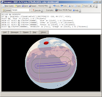
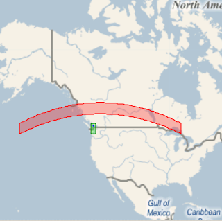
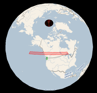
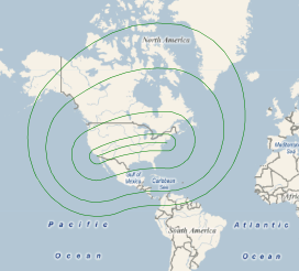
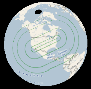
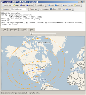
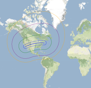
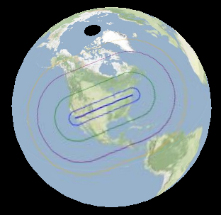
It can be difficult to visualize "geographic" straight lines (intersections, overlaps, etc) on a 'flat' projection, so here's a set of STBuffers over the LAX-JFK line... it doesn't "look" straight until you see it on a globe:


Using the 'special columns' feature of Geoquery (and a different map...)
DECLARE @g GEOGRAPHY
SET @g = geography::STGeomFromText('LINESTRING(33 -118, 40 -73)', 4326);
SELECT @g, 'Blue' AS [COLOR], 2 AS [Thickness]
UNION ALL SELECT @g.STBuffer(450000), 'Blue' as [COLOR], 1 AS [Thickness]
UNION ALL SELECT @g.STBuffer(1500000), 'Green' as [COLOR], 1 AS [Thickness]
UNION ALL SELECT @g.STBuffer(3000000), 'Purple' as [COLOR], 1 AS [Thickness]
UNION ALL SELECT @g.STBuffer(4000000), 'Orange' as [COLOR], 1 AS [Thickness]

Thursday, 17 January 2008

Geoquery: when a straight line isn't straight...

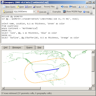
I was already aware that straight lines on a sphere (aren't really straight), but had left the correct handling of such matters out of Geoquery 0.6.

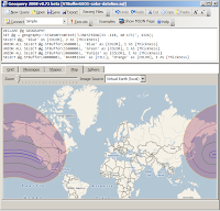
Unfortunately, this made it look rather incomplete; simply drawing a straight line over a projected map...

...isn't quite right

There are quite a few references for how to calculate the 'correct line' - I liked Ed Williams Aviation Formulary - and finally got around to giving it a try.

Here is how the query (and result) should look; with a couple of extra STBuffers thrown in...
DECLARE @g geography;
-- LAX 33°57 -118°24
-- JFK 40°38 -73°47

SET @g = geography::STGeomFromText(
'LINESTRING(33 -118, 40 -73)', 4326);
SELECT @g, null,null,null, 'Blue' as [COLOR]
UNION ALL
SELECT @g.STBuffer(450000), @g.STBuffer(1500000), @g.STBuffer(3000000), @g.STBuffer(4000000), 'Orange' as [COLOR]


The interesting thing about this canvas is the 'straight line' was the only element that I needed to programmatically 'project' -- Katmai's spatial support in the GEOGRAPHY::STBuffer() result is already a POLYGON whose points can be applied directly to the map-projection (ie. it isn't just described as two semicircular shapes joined by two parallel straight lines).

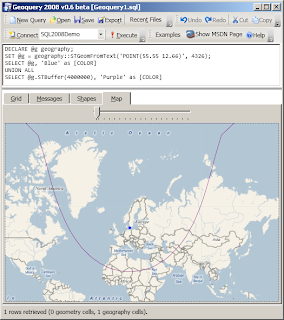
Geoquery can also correctly show buffers on points [aren't] circular on a projected map; the query from that link is reproduced below

DECLARE @g geography;
-- Copenhagen 55°37 12°39
SET @g = geography::STGeomFromText('POINT(55.55 12.66)', 4326);
SELECT @g, 'Blue' as [COLOR]
UNION ALL
SELECT @g.STBuffer(4000000), 'Purple' as [COLOR]


NOTE: Geoquery 2008 0.7 (which contains the enhancements described above) is NOT YET AVAILABLE for download. When it is available, it will also include the complete set of GEOGRAPHY Examples in addition to the GEOMETRY ones already available.

Wednesday, 16 January 2008

Geoquery 2008 v0.6 (beta)

Geoquery 2008 now supports the GEOGRAPHY datatype as well - displaying the results on a Virtual Earth map rather than a white shape canvas.


v0.6 also adds an Export... function so you can save spatial query results graphically, for emailing/reports/etc.


Here are a couple of Exported resultsets from the MSDN Sample queries...

Wednesday, 9 January 2008

Geoquery: Geography MkII

Just displaying a series of points doesn't look like much


but it can be the foundation of some neat spatial reporting - this query (attempts to) show the density of votes by postcode.

select p.postcode, p.location,
CASE
WHEN p.Postcode < 2000 THEN '#44ff0000'
WHEN p.Postcode < 3000 THEN '#4400ff00'
WHEN p.Postcode < 4000 THEN '#440000ff'
WHEN p.Postcode < 5000 THEN '#44880088'
WHEN p.Postcode < 7000 THEN '#44FFFF00'
END AS [Color]
, CASE WHEN Totalvotes < 1000 THEN 1
WHEN Totalvotes < 2000 THEN 2
WHEN Totalvotes < 3000 THEN 3
WHEN Totalvotes < 4000 THEN 4
WHEN Totalvotes < 5000 THEN 5
ELSE 6 END AS [Thickness]
from Postcodes P
INNER JOIN PollingPlaces pp ON pp.Postcode = p.Postcode
INNER JOIN PollingPlaceVotes ppv ON ppv.PollingPlaceID = pp.PollingPlaceID


Note the status bar - that's 56,951 rows!! Try loading those points into Virtual Earth! :-)