Why might we want aggregate functions on the GEOMETRY spatial datatype? Here's an example of 'how to use' the
STUnion() from MSDN: DECLARE @g geometry;On the left are the two GEOMETRYs, on the right is the STUnion() result.
DECLARE @h geometry;
SET @g = geometry::STGeomFromText('POLYGON((0 0, 0 2, 2 2, 2 0, 0 0))', 0);
SET @h = geometry::STGeomFromText('POLYGON((1 1, 3 1, 3 3, 1 3, 1 1))', 0);
SELECT @g.STUnion(@h) -- Can only STUnion two Geometries


The problem with these simple examples is they don't scale well to 'real' spatial database queries where you need to use these functions across result-sets. For example, it would be much nicer if we could insert data as follows
INSERT INTO TestShapes VALUES (geometry::STGeomFromText('POLYGON((0 0, 0 2, 2 2, 2 0, 0 0))', 0))
INSERT INTO TestShapes VALUES (geometry::STGeomFromText('POLYGON((1 1, 3 1, 3 3, 1 3, 1 1))', 0))
-- Now 'Union' all the shapes
SELECT dbo.UnionAggregate(Shape) FROM TestShapes
On the left is the result of this new
UnionAggregate query, on the left is the result after added another shape;INSERT INTO TestShapes VALUES (geometry::STGeomFromText('POLYGON((3 3, 5 3, 5 5, 3 5, 3 3))', 0))
SELECT dbo.UnionAggregate(Shape) FROM TestShapes

DOWNLOAD the source (8k) to try out the two aggregates posted on MSDN, or follow these steps:
1. Download the code from MSDN, or my copy. NOTE: You must do all these steps on a PC with SQL Server 2008 (Katmai) installed to get the
Microsoft.SqlServer.Types.dll assembly. I copied this assembly into C:\assemblies\.2. Compile the C# SQLCLR functions in C:\assemblies\ via the Command Prompt
c:\windows\microsoft.net\framework\v3.5\csc /t:library /r:Microsoft.SqlServer.Types.dll C:\assemblies\aggregate.cs3. Execute T-SQL to register the aggregate functions in SQL Server 2008
CREATE ASSEMBLY SpatialAggregate FROM 'c:\assemblies\Aggregate.dll'
go
CREATE AGGREGATE EnvelopeAggregate(@input GEOMETRY) RETURNS GEOMETRY
external name [SpatialAggregate].[SilverlightEarth.Geoquery.SqlClr.EnvelopeAggregate]
go
CREATE AGGREGATE UnionAggregate(@input GEOMETRY) RETURNS GEOMETRY
external name [SpatialAggregate].[SilverlightEarth.Geoquery.SqlClr.UnionAggregate]
go

sp_configure 'clr enabled', 1;
go
RECONFIGURE;
go
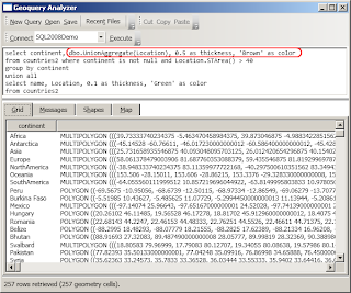
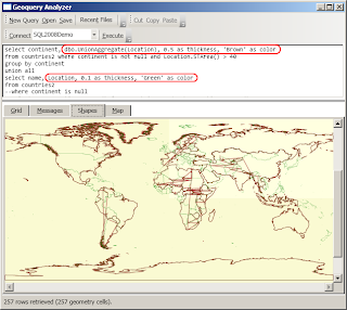
Here's another example of using the STUnion Aggregate, this time to outline continents on a GEOMETRY map. Note the
thickness and color columns are a feature of Geoquery.select continent, dbo.UnionAggregate(Location), 0.5 as thickness, 'Brown' as color
from countries2 where continent is not null and Location.STArea() > 40
group by continent
union all
select name, Location, 0.1 as thickness, 'Green' as color
from countries2

(Not sure why weird lines appear through some of the STUnion-ed geometries... something to investigate another day)
Great work.
ReplyDeleteRegarding the unexpected lines, I suspect it is from a rounding issue in STUnion. This causes all sorts of problems.
https://connect.microsoft.com/SQLServer/feedback/ViewFeedback.aspx?FeedbackID=379953&wa=wsignin1.0
Thanks Rick,
ReplyDeletewow it's funny when you read stuff that you forget writing! those lines were actually *my* bug - i wasn't "lifting my pen" between drawing the outer and inner 'geometries'. This was fixed in a later version of Geoquery 2008
i'm getting the following error when running a group by query
ReplyDeleteMsg 6522, Level 16, State 1, Line 1
ReplyDeleteA .NET Framework error occurred during execution of user-defined routine or aggregate "UnionAggregate":
System.ArgumentException: 24144: This operation cannot be completed because the instance is not valid. Use MakeValid to convert the instance to a valid instance. Note that MakeValid may cause the points of a geometry instance to shift slightly.
System.ArgumentException:
at Microsoft.SqlServer.Types.SqlGeometry.ThrowIfInvalid()
at Microsoft.SqlServer.Types.SqlGeometry.STUnion(SqlGeometry other)
at SilverlightEarth.Geoquery.SqlClr.UnionAggregate.Accumulate(SqlGeometry value)
fixed it by applying the MakeValid() function to the geom column:
ReplyDeleteselect dbo.UnionAggregate(geom.MakeValid())
from county
groupby stateid
Thanks a lot, this really saved a lot of pain. I was trying to use the SQLSpatialToll from Codeplex but that somehow didnt meet my requirement for geometry data type. This did though! You are a life saver :)
ReplyDeleteThis looks very interesting and I would like to test this, but all links are broken. Any plans to fix this?
ReplyDeleteSorry, it's almost 7 years since I wrote this! The server that most of the code was hosted on no longer exists. I'll try to look over the weekend to see if I have it backed-up anywhere...
ReplyDeleteCan we have the links working please? Thanks.
ReplyDelete